Stránka 1 z 1
App na sledovani trasy

Napsal:
ned bře 16, 2014 7:37 pmod atyp
Zdravim vsechny! Chci radu, kamos ma na androidu aplikaci, ktera si uchovava trasu, kde lyzoval, vcetne nadmorskych vysek, rozclenene do jednotlivych dnu a casu! Existuje nejaka app pro iPhone, treba i placena a ktera muze byt i bez netu v zahranici. On to ma tak, ze stahne mapy kam jede a pak staci mit zapnutou gps...! Je neco takoveho? Treba i pres cydii, ale asi lepsi pres iTunes. Ta jeho se jmenuje Locus...
Dik za rady. Atyp
Re: App na sledovani trasy
Napsal:
ned bře 16, 2014 8:29 pmod mike-biker
Sports Tracker.
http://www.sports-tracker.com/. Používám na kolo. Když se pak připojím na WiFi, tak to stáhne mapu.
Je to na na hodně druhů sportů.
Re: App na sledovani trasy
Napsal:
ned bře 16, 2014 8:34 pmod parmin
Na sjezdovky je výborný Ski Tracks
Re: App na sledovani trasy
Napsal:
ned bře 16, 2014 8:45 pmod atyp
A Ski Tracks je i bez netu?? Kde stahnu mapy? Pojedu do Italie na lyze, tak by me to zajimalo
Re: App na sledovani trasy
Napsal:
pon bře 17, 2014 1:19 amod Lukáš Valenta
Ski Tracks je asi nejlepší, používá prakticky celá skupina, už několik let. I bez internetu funguje.
Re: App na sledovani trasy
Napsal:
pon bře 17, 2014 9:08 amod bedo.
atyp:
Galileo Offline Maps je aplikácia asi najpodobnejšia Locusu, akú sa mi podarilo zohnať pre iOS (ale nemá ani zďaleka toľko funkcií, Locus zatiaľ nemá pod iOS rovnocennú alternatívu). Vie však aspoň používať rovnaké mapové podklady a vie aj zaznamenávať trasu (ale neviem ako kvalitne, túto funkcionalitu nepoužívam).

Navigation
15.06.2026 23:11
Velikost: 121 MB
Cena: US$ 0
Hodnoceni: 4.70094
od 2665 lidí


Evgen Bodunov
Guru Maps - Offline Navigation 6.2.0
Explore the world offline with Guru Maps — detailed maps, turn-by-turn navigation, and GPS track recording that keep working when you have no signal.
Download maps once and use them anywhere (powered by OpenStreetMap). Plan routes, record adventures, save favorite places, and sync everything across devices.
OFFLINE MAPS
• Download maps for countries or regions and use them fully offline.
• Rich detail and millions of places. Monthly map updates.
NAVIGATION THAT WORKS OFFLINE
• Voice-guided, turn-by-turn directions with automatic rerouting.
• Lane guidance for clearer driving in complex junctions.
• Modes: car, bike, truck, walk, plus straight-line navigation (great for sailing or off-road).
ROUTE PLANNING
• Build multi-stop routes with custom waypoints.
• Choose fastest or shortest route and save your plans.
• Export routes to GPX/KML to share or back up.
TRUE 3D RELIEF & TERRAIN
• Preview hills and valleys in True 3D Relief.
• High-detail terrain: contour lines, hillshade, and topographic overlays.
• Elevation profiles and slope charts for smarter planning.
GPS TRACK RECORDING
• Record tracks with one tap (even in the background).
• Live stats: speed, distance, time, altitude.
• Analyze tracks with interactive graphs and export to GPX/KML.
FAST OFFLINE SEARCH
• Search by name, address, category, or coordinates — offline.
• Instant results as you type, with multi-language support.
POI & ORGANIZATION
• Save places with custom pins and icons.
• Organize everything into folders and share with friends.
OPENING HOURS
• See opening hours for places when available.
SYNC ACROSS DEVICES
• Sync and back up your markers, tracks, and collections with one Guru Maps account across iOS, macOS, and other platforms.
CARPLAY
• Use Guru Maps on Apple CarPlay with offline maps and voice directions.
NO ADS. PRIVACY FIRST.
• No advertising. Your location stays on your device.
Power features: one-finger zoom, compass & scale, coordinate grids (MGRS/UTM), GeoJSON overlays, MBTiles/sqlitedb import, and more.
Upgrade to Pro for:
• Unlimited offline map downloads
• Unlimited markers and GPS tracks
• Pro map sources, including Satellite and specialist layers (cycling, outdoors, marine, ski, etc.)
Choose monthly or yearly subscription (7-day free trial) — or a one-time lifetime purchase.
Download Guru Maps and explore with confidence — anywhere, anytime.
Terms of Service & Privacy Policy: https://gurumaps.app/terms_of_service
Continued use of GPS running in the background can dramatically decrease battery life.
VÍCE O APLIKACI

Re: App na sledovani trasy
Napsal:
pon bře 17, 2014 9:13 amod atyp
A umi to i bez pripojeni na net v zahranici? Jak to dela? az po pripojeni na wifi nebo 3G se sthnou mapy?? Nebo si musim mapy stahnout predem? Je to Offline, tak asi napred stahnout a do nich se to postupne zapisuje, ze??
Ten Locus mel super to, že mu to ukazalo i sjezdovku pres Google Earth a videl, jaku rychlosti jel a pod. Roztridene podle dnu.
Diky za odpoved. atyp
Re: App na sledovani trasy
Napsal:
pon bře 17, 2014 10:45 amod ls8
Re: App na sledovani trasy
Napsal:
pon bře 17, 2014 11:04 amod atyp
at se propadnu, vcera jsem ho tam hledal a nenasel....! Diky
Re: App na sledovani trasy
Napsal:
pon bře 17, 2014 5:45 pmod bedo.
ls8 píše:Locus je i pro iOS
To je ale úplne iná aplikácia, len názov je rovnaký.
Galileo zvládne rovnaké mapy ako Locus (pre Android), ktoré sa dajú pripraviť dopredu napr. v programe
MOBAC. V závislosti od dostupných zdrojov to potom môžu byť rôzne mapy vrátane Google, Bing, OSM, či lokálne topo mapy. Nová verzia podporuje aj vektorové mapy - u tých je fajn, že celá krajina kľudne zaberie len 80-100MB, ale zatiaľ som ich neskúšal.
Napadol ma ešte jeden dobrý program, v ktorom sa tiež dajú mapy stiahnuť dopredu (priamo z programu, ale len zo zabudovaných zdrojov) a vie aj pekne robiť záznamy. Volá sa
Maps3D.

Navigation
06.05.2024 09:21
Velikost: 26 MB
Cena: US$ 3.99
Hodnoceni: 4.38725
od 204 lidí

movingworld GmbH
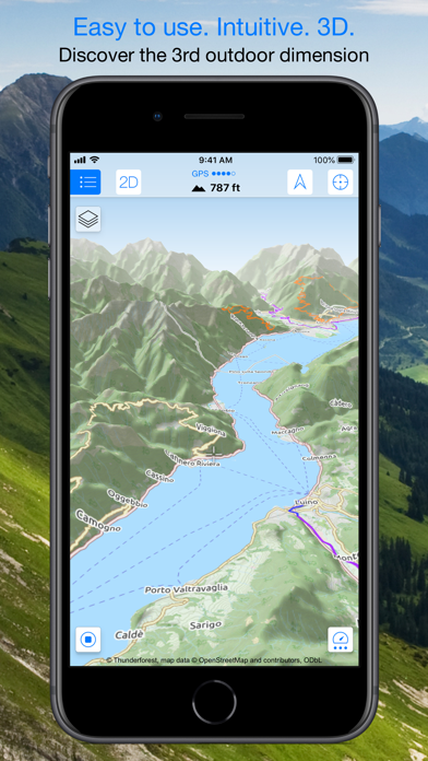
Maps 3D PRO - Hike & Bike 6.8
Enjoy exploring the great outdoors? If you’re a fan of biking, hiking and running then Maps 3D is the ideal app designed for planning your outdoor adventures. Whereas other mapping apps are primarily designed for cities and roads, displaying hills and mountains as flat and lifeless features, Maps 3D is packed with amazing features that brings the great outdoors to vibrant life with valleys, hills, mountains and footpaths displaying in full 3D so you’ll know your exact elevation.
*** Featured by Apple with a main banner in the US App Store Navigation category! (02/2013)
*** 3rd place at the '2013 Best App Ever Awards' by 148apps.com in 'Best Outdoors Apps'
*** Over 1,700,000 global users!
*** TOP 1 App in Navigation in 75+ countries (as of 01/2017)
*** "The functions are helpful; the compilation of 3D maps is impressive." Macwelt.de – Score: 1.8
*** "An app recommended for hikers, cyclists and horse enthusiasts..." iPhone & iPad apps in Test Magazine, issue 3/2011 – Score: 8/10
STORE ROUTES & USE OFFLINE
With Maps 3D you’ll have the option to plan, record and share your routes, turning your iPhone into a fully-fledged GPS device so you can log key coordinates and elevations. You’ll also have offline access to worldwide 3D map data which limits the drain on the battery and means that you can pre-load maps to store when you don’t have a signal.
SEARCHABLE MAPS
As an added bonus Maps 3D offers 3D terrain and trip planning, so you’ll never need to worry about getting lost. Towns, streets, mountain peaks and lakes are all searchable, with an accurate and precise map display based on NASA scans of the Earth’s surface combined with the outdoor map OSM (Open Street Map) and the Official USGS topo maps.
LOAD YOUR TRIPS & SHARE
GPX-tracks can be imported via iTunes, email, URL or Dropbox, and recorded tracks can be shared via email, Facebook and Twitter, great for showing your friends your latest outdoor accomplishments.
MORE FEATURES
+++ Load maps in advance over WIFI or 4G before your trek, no internet connection needed thereafter
+++ Record your routes by GPS, all coordinates and exact elevations are logged
+++ Plan and evaluate routes directly in the 3D map view
+++ Search for towns, streets , mountain peaks, lakes - offline
+++ Distance traveled, current and average speeds all displayed for an ideal trek
GENERAL / NOTES
Background GPS recording can significantly cut battery life
* * * * *
If you like Maps 3D, please remember to leave a positive rating on iTunes!
The movingworld team is working constantly to improve Maps 3D. Any suggestions? We'd love to hear them! Just e-mail them to us at support@movingworld.de. We'll try to answer you within 24 hours!
Thank you for using Maps 3D!
VÍCE O APLIKACI
Re: App na sledovani trasy
Napsal:
pon bře 17, 2014 6:06 pmod atyp
Maps 3D ma stejnou grafiku jakou mel kamos na andridu, videl krasne kudy jezdil, kolik najezdil, vse ve 3D! Parada! Ten locus jsem si zaplatil, stahnul a je uplne naprd! Nestahovat! Ma nekdo dobrou zkusenost s Maps 3D? At zase zbytecne neplatim..! Podle screenu to vypada perfektne! Dik
Re: App na sledovani trasy
Napsal:
pon bře 17, 2014 7:03 pmod bedo.
Ja ho mám už nejaký ten rôčik (podobne aj Galileo, Locus, OruxMaps, RMaps a ďalšie, väčšinou teda pre Android) - Maps3D je dobrý program a tým 3D zobrazením aj trochu unikátny (to nemá ani Locus), trasu zaznamenáva spoľahlivo, v podstate jediné obmedzenie je to, že na výber sú len OSM mapy (a USGS v Amerike). V tom je zasa dobrý ten Galileo, do neho nahráš (s pomocou MOBAC-u), kľudne aj staré ruské vojenské mapy Afganistanu.

Čiže by som asi vyberal podľa toho, o čo Ti ide primárne - či o dostupnosť mapových podkladov (vtedy by som doporučil skôr Galileo), alebo o záznam trás, s tým, že sa uspokojíš s tými mapami, ktoré sú v Maps3D zabudované.
Re: App na sledovani trasy
Napsal:
stř bře 19, 2014 8:12 pmod Clon
Zkus se taky mrknout, jestli tě nezaujme něco z rodiny Runtastic programů.
Re: App na sledovani trasy
Napsal:
stř bře 19, 2014 9:39 pmod atyp
Jediny co by tal za zminku je asi "Ski and Snowboard Tracker" ale to nevim, jestli pracuje bez netu jen na GPS ( cena 4.99 Euro ).
U nej to funguje jak? Stahnou se predem napr na wifi mapy oblasti kam pojedu vcetne terenu a pak uz je to jen na GPS??
Dik za info